Leg 2 – 2016, Update 1
June 17, 2016, 1500 hrs, 72.05 N, 19.23 E, Log: 194,124 miles
Baro: 1013.6, Cabin Temp: 62 F (without the furnace on!), Cockpit: 50 F, Sea Water: 48.6F
Closehauled and double-reefed into 16-18 kt NE winds with slight seas
Barents Sea, 120 miles south of Bjornoya (Bear) Island
SPITSBERGEN, HERE WE COME!
For a few days between Legs 1 & 2 Amanda and I managed to slip away from bustling and booming Tromso to intensely enjoy a quiet anchorage off tiny Finnkroken Village on Reinoy Island, 12 miles but many years away from Tromso. Amanda managed to catch a cod every time she tried her hand at fishing and we had long runs, hikes and exploring hitchhikes ashore. The anchorage was especially appealing because in every direction we could see snow-capped peaks and a steady parade of passing vessels kept us entertained with their AIS information. They ranged from freighters, cruise ships and fishing vessels to state-of-the-art 200’ salmon farm tenders and their destinations and home ports varied from Svalbard, Faroes, Iceland or just further north along the coast.
In Norway refilling our new US propane tanks had proven impossible until, on the advice of Norwegian Cruising Guide we tracked down LPG Tromso, a few miles out of town above the private Skatorra Marina. Because of the challenge of refilling, I asked Ole, the owner if he had any old LPG tanks he wanted to sell, and he ended up giving us a 5kg tank that was out of date but had a compatible hose fitting.
Following our Wednesday 4-6 pm safety briefing our eager crew researched first night anchorages, and within minutes of their arrival Thursday noon, we set sail, first for Finnkroken where our crew landed a couple cod in the misty drizzle, then for a dinner stop at Torsvag, a small fishing and whaling port and the very last stop before jumping off for Bjornoya and Svalbard.
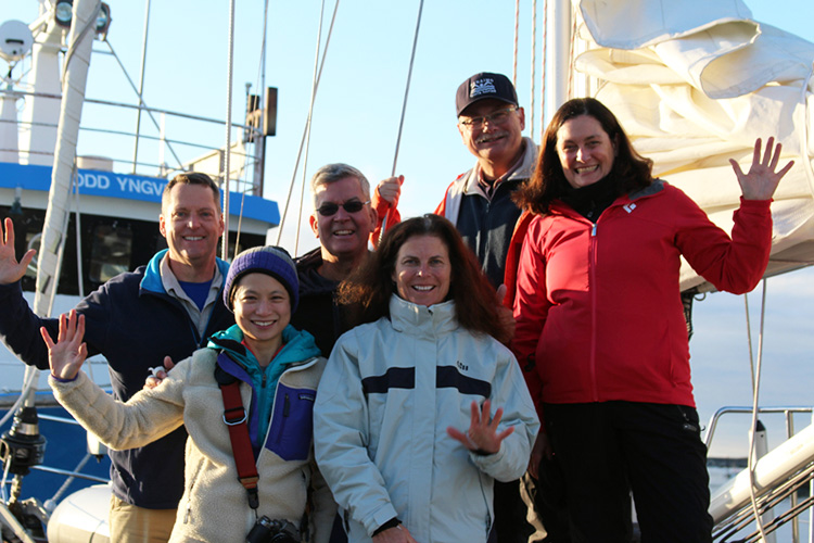
Leg 2 Crew
We had earlier planned to spend the night in Torsvag, but from all indications on www.windyty.com, www.yr.no and from our very recent Commanders Weather Forecast, it looked like we would end up experiencing northerly headwinds of 20-25 kts for several days if we were to stop for the night. All forecasts indicated we had a narrow window to get north before fresh northerlies developed, and so far we have been successful, although it required some motorsailing in 6-10 kt winds at the start.
Until early this morning we had nearly constant fishing and occasionally freighter traffic visually or on AIS, but now we are alone, except for several visits from whales this morning. One was so close that Kevin had to quickly change course to avoid a collision.
We enjoyed a brief visit to Bjornoya Island on our 2007 expedition but it looks like this year we may get to enjoy several days exploring while we wait for favorable winds for the second half of our passage to Svalbard. Tom, our navigator of the day has been researching possible anchorages and has found one on the SE end of the island used by polar explorer Fritjof Nansen to refill water casks at a shoreline waterfall.
Leg 2 – 2016, Update 2
June 21, 2016, 0500 hrs, 76.47 N, 14.43 E, Log: 194,465 miles
Baro: 1009.3, Cabin Temp: 60 F (without the one furnace on), Cockpit: 50 F, Sea Water: 40.1F
Closehauled at 7.1 kts without reefs 16-18 kt NE winds with slight seas
11 miles west of Hornsund entrance, Spitsbergen
STEADY WINDS AND A FAST PASSAGE!
With a contrary current and light winds from the direction we wated to go, we motored the last few miles to our Bjornoya (Bear) Island landfall at Sorhamna on the SE corner, giving us the opportunity to run the watermaker, warm up the water heater and enjoy hot showers before anchoring. What a luxury!
 On approaching Bear Island Kay and LaVerne drop the main |
Sorhamna is mentioned in the cruising guides as being by far the best anchorage on the island, and we could tell why. Surrounded by cliffs on two sides and an island close to the east, it is only open to the south and has a sandy bottom with modest depths allowing us to anchor securely in 22’ at 1900. After a yummy cod curry dinner, we double-checked the anchor, gazed about at the impressive surroundings and slept like babies until the following morning.
Sunday was busy with engine room orientation, safety systems and reefing test and while Amanda taught liferaft and Lifesling launching I did an engine oil change.
 As we were eating lunch, we heard a siren and popped on deck to discover an impressive Norwegian Coast Guard boarding vessel approaching. |
We welcomed the Coast Guard inspection officers aboard and they told us their icebreaker/patrol vessel was nearby and that they’d been aware of our AIS presence for more than two days. The southern end of Bjornoya Island is off limits for yachts over 40’ to approach or anchor, but Sorhamna was just north of this area, so we were ok. The inspectors were mainly ensuring we were aware of the rules for Bjornoya and Svalbard and asked our crew if they felt safe (which brought some laughs!). After the formalities, which included a stern warning of the dangers of polar bears, they shared some of their favorite Svalbard anchorages and information on additional bays to the north of Longyearbyen. Before long they were off to board and check several large (220’ to 450’) Russian fishing vessels
 Mahina Tiare anchored in Sorhamna |
anchored well offshore.
We launched the RIB and motored slowly along the shoreline, marveling at the thousands of nesting seabirds lining the cliffs. There was a sandy beach where we could have landed, but vertical cliffs meant very little hiking if we did land, so we raised anchor and headed north along the coast, passing a 67’ whaling vessel, complete with harpoon gun on the bow before anchoring in Austervag Bay, site of an abandoned coal mine.
 Norwegian whaling vessel |
Although sheltered from the now westerly wind (one of our reasons for stopping was to wait until the wind shifted from NNW to W), a powerful swell was wrapping around the N end of the island making the anchorage very rolly. Any ideas of going for a hike were quashed by impressive surf on the beach so instead our eager gang piled into the RIB and we cruised the shoreline, checking out the extensive ruins of the coal mine which ceased operation in 1910.
It was 2200 by the time we’d finished dinner, and wanting to take advantage of the favorable forecast, but also not wanting to rush we decided on two hours of sleep, followed by raising anchor and setting sail at 0000. It takes a bit of getting used to, having it nearly as bright at midnight as noon, but it sure makes getting underway at all hours easy.
Once at sea we found 20 kts, gusting 29 upon rounding the northern tip of the island, making us glad for having tucked two reefs while hoisting the main. We were able to just lay course to clear Sorkapp, the southernmost tip of Spitsbergen, but it was rough, partly due to the relatively shallow depths and opposing swells.
 Tom and Jamie happy to be sailing |
By Sunday night the winds were down to 20 and had backed to the SW as forecasted, allowing us to ease sheets and enjoy some great sailing. We’ve now been paralleling the coast for several hours but have only seen land on the radar because of hazy conditions. Currently we’re passing (10 miles off) the entrance to Hornsund, home to a Polish research base and several spectacular anchorages. We’d love to stop but before landing we’re required to check in with the Sysselmannen (governor) and pick up our rental (required for polar bear protection), so in order to do so we’ll continue on another 120 miles to Longyearbyen, the capital and only commercial settlement.
June 25, 2016, 1140 hrs, 79 53 N, 11.43 E, Log: 194,465 miles
Baro: 1013.8, Cabin Temp: 60 F (without the one furnace on), Cockpit: 51 F, Sea Water: 42.1F
Motorsailing at 7 kts back from 80 N in 5 kt SSW winds and calm seas
6 miles N of Sallyhamna, Spitsbergen
WALRUS, BELUGA WHALES AND POLAR BEARS!!!
Our landfall in Longyearbyen, capital of Svalbard was at 2355 and we were surprised and delighted to find one of the two floats reserved for visiting yachts totally empty. Ishmael, a guide on a small expedition ship anchored nearby was leaving by RIB and said we’d need to check with the harbormaster in the morning, but as far as he knew, we should be fine using the berth for the rest of the night. Perfect. Our plan was to do our town errands and be away by noon.
We were awakened at 0500 by the sound of the pilot boat departing and looked out across the wharf to see the huge hulk of the Pacific Princess cruise ship drawing alongside. I ran ashore and asked a line handler if we could leave before the ship’s stern lines boxed us in and he said “There’s the harbormaster, ask him”. The harbormaster was Kjetil Braten, same delightful guy who we’d gotten to know in 2007 and as I ran up, he yelled, “Too late! You’ll be here for the day”. He asked why I hadn’t tried calling him on the VHF and I said, “It was nearly midnight”. He replied that he always sleeps with channel 16 on and that he’d have advised us that if we used the slip we’d be boxed until 1700.
 MT berthed at the yachts pontoon and boxed in by the Pacific Princess |
 Reindeer graze in the valley before the town Longyearbyen |
Never mind, it wasn’t a problem as crew enjoyed showers, laundry and exploring the town and museums before we set sail for Trygghamna, 24 miles away.
What an incredible two days we’ve had since leaving Longyearyen. First night we anchored in front of an actively-calving tidewater glacier in Trygghamna (Safe Harbor), formerly a favorite anchorage of whaling ships. We got an early start Thursday morning and were amazed at the number of walrus we saw ashore at Poolepynten Point. In a flash we’d anchored, launched the RIB and hiked down the beach.
 We stayed a discreet distance from the pile of walrus huddled on top of each other. |
 Only two walruses occasionally looked unconcernedly at us, while another walrus of swam back and forth along the shoreline. |
 John instructs crew on the safe operation of our rented rifle for polar bear protection |
Just about when we were going to head back to the dinghy, five beluga whales swam slowly and very closely by. This was our first-ever beluga sighting anywhere!
 Our dinghy heading ashore from our Magdalena anchorage |
Our anchorage that afternoon was Engelsbukta, and not long after we anchored, ten reindeer showed up ashore to watch us as they grazed along the hillside. We thought about landing and hiking up the hillside, but the 15 kt southerly winds on a lee shore would have made for a wet, boot-filling landing, so Amanda taught Sail Design and Sail Trim classes.
Yesterday we got another early start and diverted around halfway to visit Magdalena Fjord, site of a Syssellmanen guard hut. Previously we’d found the park guards an excellent source of info on where bears had been sighted, but Martin and Ole had only recently arrived and didn’t have any sightings to report. We welcomed them aboard for hot showers, but they busy completing repairs to their boat, having sliced it open on an unseen bit of ice.
 Martin (wearing black hat) shares the history of the whaling site and grave yard |
 Never wanting to arrive empty handed, we presented Martin with a very-welcomed bar of dark chocolate |
We continued north in the afternoon. Over the period of an hour, we passed four southbound expedition sailing vessels, and I called each one on the VHF, asking if they’d seen bears. All said no bears, except for the last one, mentioning they’d spotted bears in Hamiltonbukta and across to the eastern shore of Raudfjord. We immediately changed our destination from Sallyhamna to Hamiltonbukta which would be a totally new fjord and anchorage for us.
 Sailing past a small piece of brash ice |
 Tom and Carol on whale lookout |
 We all spent hours scanning the shoreline and partially snow-clad slopes of the anchorage for bears spotting some tracks, but no bears. |
The pilotage information in Norwegian Cruising Guide for Hamiltonbukta is somewhat confusing, but we slowly crept in to what was a spectacular anchorage; quite close to a calving tidewater glacier which afforded an expansive view of some of Svalbard’s highest peaks under a nearly cloudless sky. The beauty surrounding us was simply astounding.
After we’d anchored I’d called Ocean Nova, a small expedition cruise ship managed by Quark Expeditions that had anchored a few miles away, asking if they had seen any bears. They said hadn’t seen any in the past week.
This crew is having a laugh a minute. After dinner Jamie and Tom had us playing The Cookie Game: Everyone places a cookie on their forehead and on “GO” you have to get the cookie onto your mouth without using your hands. It requires a lot of face scrunching and tongue work.
 Jamie about the win a cookie game against Tom |
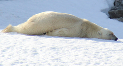
This morning I was still sleeping when I heard an eager bear-watcher on deck. I’d overslept! With only one brief look ashore for bears, I cleared the engine room of drying boots, socks and gloves as the bosun of the day started raising the anchor. Our original plan was to again sail to the edge of the ice pack as in 2007, however the ice pack was currently 200 miles north so that idea was out. LaVerne, navigator of the day, proposed we head across and up Raudfjord to check out the passing expedition yacht’s bear sighting before sailing 12 miles north to 80 North, and then further east to Woodfjord for the evening anchorage.
We’d only started raising anchor when Kevin, who had been looking out the window below said, “Do you see the polar bear there on the beach?” He was pointing directly shoreward from us where a very active young bear (possibly a three-year-old) had just swum to the shore and was climbing out of the water. The polar bear started ambling north along the beach, not more than 150’ feet off our bow. We stopped raising the anchor and I said, “Let’s get the dinghy in the water ASAP and follow him along the beach. Amanda – get the gun!”.
Once the dinghy was in the water and outboard lowered and attached, I asked for the fuel tank and hose to be handed down, only to learn there was no fuel line, anywhere. All I can think is that at Magdalene Bay in my hurry to get the dinghy back aboard I must have disconnected both ends of the fuel line, handed up the fuel tank and left the fuel hose in the bottom of the dinghy. It must have slipped into the water when we hoisted the dinghy vertically to then lay it down on the foredeck.
So…we stowed the dinghy, raised anchor, motored slowly through a pod of curious beluga whales and for three incredible hours, followed the bear a it walked north along the waterfront and swam around numerous headlands covering a total of 3.5 miles.
Upon settling in to our bear watching I called Ocean Nova and told them of our sighting. The watchstander asked me to standby, and a minute later, I was speaking with John, the Aussie cruise director who excitedly told us he could see our AIS position on their radar, and thanked us profusely, asking after the general health of the bear. He also asked if it would be ok if they steamed closer to us and launched their Zodiacs with passengers. I assured him that would be fine and asked if they might have a spare outboard fuel line. John said he’d ask the bosun to locate one and said they’d be underway ASAP. It was an hour before Ocean Nova hove into view, but while they were still several miles off, John said they’d already spotted the bear.
 The polar bear knew we were there, as he would glance unconcernedly at us now and then. |
It was great to watch the polar bear. It was really on the move and tried to avoid walking in the snowy patches preferring to step from rock to rock. After two hour of walking and swimming he put his head and front paws onto some snow and for 100’ slid along using his hind legs before coming to rest on the snow for a few moments. Next he was rolling over onto his back with paws in the air before getting up to continue walking. At one point we anchored in just 12′ of water, directly off the snow-covered slope where the bear was taking another nap on a mossy ledge but just before the five large Ocean Nova’s Zodiacs started to arrive, the bear was up and on the move again, so we raised anchor, but held back so their guests could all get a great, unobstructed view and photos.
 Nap Time |
 Playing in the snow |
The last Zodiac came directly toward us, instead of heading to the bear and John, the jovial Aussie at the helm came alongside, handing us a brand new Yamaha fuel line with a great big smile. When I tried to pay him, he just said, “Bugger off, mate, we’re happy to help you! You lot are all invited aboard for drinks and dinner if we ever share an anchorage or port!”. He had four of expedition and ship’s crew but no passengers aboard his Zodiac, and explained that they were ecstatic to be able to have this bear sighting for their guests. He also related how on a previous expedition he’d sighted several starving bears at Andoyane Islands in Woodfjord, 30 miles to the east also relating that Woodfjord had unusually remained ice-free the past winter, with few if any seals for the bears to hunt.
 John and crew from Ocean Nova deliver a new outboard fuel line |
 Ocean Nova on standby, waiting for the return of her Zodiacs and passengers |
At this point, we decided to resume our planned schedule of heading 11 miles north to pass the 80 degrees North latitude, which we did.
 Our accomplished 80 degrees North crew: LaVerne, Kevin, Carol, Tom, Kay and Jamie |
LaVerne, 59
I love the Arctic and all its flora fauna and glory and hope to do more high latitude sailing when not engaged in outdoor adventures. I practice law in Seattle and upon leaving Svalbard I’m headed to Norway’s Lofoten Islands on a sea kayaking adventure.
Kevin, 63
I recently retired after being a pharmacist for over 40 years on Vancouver Island and now that my three boys are on their way I’m looking to re-start my sailing career. Pre-children I did the Vic-Maui plus 15 Swiftsure races. My wife is meeting me in Scotland following this expedition and we’ve chartered a 29’ sailboat to sail the Caledonian Canal. I’ll be looking for other boats to crew on, hopefully including an Atlantic crossing this November.
Carol, 44
Originally from Hong Kong, but now based in London, I’ve spent the last 20 years managing commercial infrastructure projects (airports, mass transit and tunnels) on four continents. Now my sailing goal is to explore by sea areas of the world untouched by zealous builders and mass population. Other interests when not sailing include skiing and sharing good food and wine with friends.
Kay, 61
I am the mother of three boys, a physician and former veterinarian originally from Wisconsin, but have spent the last 36 years in the Pacific Northwest and am now eager to retire after 20+ years in OB-GYN and hoping to begin blue water cruising, diving and exploring the world. I’m looking for a like-minded soul to join me.
Jamie, 57
I am a sales guy who loves adventure and travel. When I was young, I biked around the world, and Tom joined me on part of that trip. Now I am looking at sailing which is much easier on the body. I only sailed on one-week adventure before this trip, and this was my first overnight sailing – it was fun! Be fearless and get out of your comfort one and learn something!
Tom, 56
I am an American tax lawyer working in Munich, but always looking for cruising opportunities. I’d like to do an ocean crossing at some point and John and Amanda have helped me make great steps in that direction.
It was now decision time. For several days a southerly of 25-30 kts had been forecasted for Sunday, the day we’d been heading south on an exposed leg of our return trip to Longyearbyen. Should we continue to sail 30 miles further away to Woodfjord to look for starving bears, or, count our blessings (and sightings) and set sail to Ny Alesund, 110 miles south, stopping at nearby Sallyhamna for lunch and to check out the 250-year-old trappers cabin?
 After enjoying a pleasant wander and crew photo at Sallyhamna our crew unanimously chose to head south |
We pushed on through the evening arriving at Ny Alesund at 0030 Sunday morning. When I’d called the harbormaster several hours earlier, he said he’d be up and would show us where to tie up. Surprisingly the T-pontoon at the end of the small boat dock was open and Aspeth, a shy carpenter/engineer from Bodo took our lines and invited us to the “summer party” in the boathouse overlooking the harbor which was in full swing. 30 or so people were dancing in wacky costumes to everything from the Beach Boys to Neo funk and through the binoculars spied a children’s swimming pool overflowing with glacier ice and beer cans.
Later that morning after we visited the excellent always-open self-service museum and had a wander around town, I raised Aspeth on the radio, and he came down to the main wharf where we’d rafted to a research boat and were able to top our fuel tanks up.
 MT berthed at Ny Alesund |
 Crew wandering up Ny Alesund’s main street |
We headed south, motorsailing into ever-increasing headwinds gusting to nearly 30 kts before seeking shelter at the glacial face in Inglesbukta where we found a very protected and surprisingly secure and dramatic anchorage. Amanda pulled out the sewing machine and taught sail repair.
Monday we had a leisurely (for us) 0600 departure and in sometimes dense fog, light winds and occasional drizzle motored 45 miles south to Farmhamna. After lunch it was still foggy so we waited until after class (electrical power systems and watermakers) before heading ashore. We were concerned about being able to spot any polar bears in the fog, so stuck close together as we enjoyed a ridge walk and a very curious reindeer that kept us well entertained. It seems that all of the animals in Svalbard are curious and fearless around humans.
Tuesday morning to fog totally lifted as we entered Isfjord (the fjord that Longyearbyen is located on) and the minute the wind arrived, we started practicing Lifesling overboard retrieval. As usual, our expedition members said, “Why weren’t we taught this simple method (modified Quick-Stop procedure) instead of the ridiculous Figure 8 or Deep-Beam-Reach methods.
 LaVerne returns to the helm after deploying the Lifesling |
 Next on the teaching schedule were sextant sights for latitude by noonsite and with a glassy calm sea, everyone enjoyed taking multiple sights. |
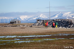
Kevin was our navigator of the day, and we asked him to, with the input of the rest of the crew, choose an anchorage for the night. Options included the active Russian coal mining town of Barentsburg, the nearly abandoned Russian mining town of Pyramiden or Scansbukta, a quiet and magnificent anchorage surrounded by bird-filled cliffs and sight of an abandoned Swedish gypsum mine.
Scansbukta was the choice and once the anchor was down at 1430, Amanda taught going aloft for rig inspection before we launched the RIB, landing ashore to check out the abandoned mine, shipwreck and trapper’s hut.
 Carol’s masthead view of the mine and hut at Scansbukta |
 Ashore at Scansbukta |
 Scansbukta’s impressive horizontal sedimentary strata cliffs |
Upon returning we reanchored on the other side of the bay which afforded us an amazing hike Wednesday morning. LaVerne taught us the names of the tiny flowering plants that blossom and thrive in the few snow-free months, Kevin found fossilized shellfish high on the slopes and we all enjoyed a close encounter with a ptarmigian before heading down the mountain.
I joked with our crew, saying that I was visualizing a place for us to moor alongside in Longyearbyen (instead of anchoring out) and true to form for this expedition, there was (unusually!) one open spot on the pontoon which normally is rafted three-deep, just perfect for Mahina Tiare! In minutes our crew were headed for showers and laundry, but thanks to LaVerne’s keen persistence, we all sat down and worked out the sextant noon site before they headed up town.
We enjoyed an amazing dinner at Kroa, a trapper’s hut-themed restaurant which serves whale, NZ lamb plus excellent fish. Everyone was happy and joking around, and we all agreed that the group just “clicked”!
Someone had noticed a poster in town inviting all to an open house aboard the Greenpeace ship, Arctic Sunrise and although we arrived after their stated hours, the Greenpeace crew welcomed us aboard and allowed to tag on to the end of a tour. In the ship’s hold we learned that because the southern limit of the pack ice is rapidly receding north annually, there is now huge pressure from the Russian and Norwegian bottom trawlers to fish these pristine waters. We know from talking with scientists that the 200’ – 250’ bottom trawlers drag large steel trawl doors along the ocean floor, disrupting and displacing all sea life. Greenpeace is wisely campaigning for a fishing moratorium long enough for base line species surveys to be conducted. They’re also asking for countries to go slow on the rush toward Arctic oil drilling, based on the extremely hazardous ice conditions and vulnerability of the seafloor, plants and animals. We certainly support these requests.
Also in the hold of Arctic Sunrise they were displaying an amazing video, filmed last week at the nearby glacier, of a piano piece played by the composer Ludovico Einaudi. Click here to view.
 Greenpeace ship Arctic Sunrise |
 Crew strike a pose for the environment aboard Arctic Sunrise |
Several days have passed, and Mahina Tiare is currently anchored off Kapp Wijk, 20 miles N of Longyearbyen, as Amanda and I wait out a blow. The barometer is rising, winds are down from 24 to 14 kts and the sun is breaking through. Now that we’re caught up with sorting images and completing this update, it’s time to launch the dinghy and explore the shoreline and historic trapper’s huts! We sure do love Svalbard.
Resources used for Leg 1, Orkney, Scotland to Tromso, Norway:
Weather:
YR.NO: NRK Met Institute – Norwegian government weather site which we think must use the EC forecast model. Incredibly accurate and helpful with very detailed coverage of Svalbard!
WINDYTY.COM: Worldwide GRIB forecast charts utilizing US GFS computer model.
Cruising Guides:
Norwegian Cruising Guide, 7th edition, Volume 3 covering from Kristiansund to Russian border, Phyllis Nickel & John Harries, Attainable Adventure Cruising, Ltd.
Norway – RCC Pilotage Foundation, Judy Lomax, 2nd edition.
Den Norske Los, Arctic Pilot – Svalbard and Jan Mayen (available free as a PDF from kartverket.no)
Charts:
British Admiralty: 2228, 2751
Norwegian: 503, 504, 510, 521, 522, 523
Electronic Charts:
Navionics running on Raymarine MFD
C-Map running on Rose Point Coastal Explorer on PC
Leg 2 Itinerary